On a quick trip to the Denver area. After my appointment, I still had time to squeeze in a short hike before making my way back to the airport.
Sunny but very cool day (in the 40s). Heading to Castlewood Canyon State Park (6100 ft) for a short hike. The park is about 5 miles south of the town of Franktown (south and a bit east of Denver). I've never been there before (obviously) so this will be fun.
The park is around 2600 acres in the "ecologically unique Black Forest region of Colorado" - lots of Ponderosa Pine.
I turn right off the RT83 heading into the park and I immediately see a very large herd of pronghorn just outside the parks boundary in the grasslands. Awesome!!
After watching them for a bit, I head to the gate, pay my admission, drive to the 1st parking lot and start down the Canyon View Nature trail. The "trail" is a concrete sidewalk. A bit disappointing but it does make things more accessible. (I'm sure there are other trails.) As I head down the side walks, there are lots of picnic tables and other sidewalks going in different directions.
I see some low growing cactus, rocks and lots of Ponderosa Pine trees.
Although all the sidewalk branches are a bit confusing, I keep walking in the direction of the canyon and find an overlook.
And then another. (I can see Cherry Creek below)
The trail continues but I decide to turn around and head back to my car so I can head to the final parking lot and hopefully some real trails. It's a real short drive to the next parking lot. There I start down the Lake Gulch Trail (0.8 miles). The trail heads in the northerly direction. I reach the Pikes Peak overlook very quickly and take the short detour to the overlook. It's too sunny and hazy to see the Peak - perhaps at sunset. But below is a large grassland with some cows (just small dots).
Pretty quiet - except for the cows mooing.
Continuing on the views of the grassland continue to my left but to my right it gets pretty rocky as the trail drops (about 200 ft) to that grassland. Looks a little like southern UT but much smaller. :)
The trail "ends" at the creek (that runs down the canyon).
I have to cross the creek on some large boulders.
That's the end of the Lake Gulch Trail. Now I can either head back on the Inner Canyon Trail or continue onto the old dam on the aptly names Dam Trail (0.35 miles). I want to see the dam (and I have plenty of time) so I continue on thru up a small hill and continue along the grassland.
The Castlewood Dam was built in the 1890s to contain water for farming and people. No different than today.
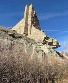
On Aug 3, 1933 the dam broke after a multi-day heavy rain event flooding some 34+ miles to Denver. And this is all that remains of the dam.
I can continue up to the remaining portion of the dam or continue below on the Creek Bottom Trail (1.7 miles). Just before I reach the dam, I actually see some wildlife - a Chickadee!
I pass below the dam and continue along the creek.
I'm not heading the entire 1.7 miles (just don't have the time); however, I do want the reach the waterfall (which looks to be around 1 mile down the trail).
I'm now following along the creek.
I'm in the very cool shade now. There's light snow on the trail. This is rattlesnake country (one was seen along this trail on Oct 29) but it's shady and cold, I don't think any snake would be out today.
The creek is visible in spots but mostly it's hidden behind boulders. but it's still very pretty especially the cliff on the other side of the creek.
Soon I see a wooden fence and a big drop-off on the other side. I turn around and there's the waterfall (still flowing!!)
I continue along the trail until it ends just past the falls. (The trail actually continue but there's steps involved.) Time to head back.
Soon I'm back at the start of the Inner Canyon and Lake Gulch Trail. Part of me wants to take the same way back and be in the sun. But I have to complete the loop and head down the Inner Canyon Trail (1.1 miles) along the creek. I'm not sure how I'm going to get across but I trust the map that I will be able to get across.
Lot's of rocks along the trail with good views of the creek. The trail follows the edge of the forest.
Not far down the trail, I see my 2nd bird of the day -- a Brown Creeper (I think).
I expecting my crossover to be wide open as it was on the Nature Trail so I keep looking as I walk. (All forest on the other side.)
Soon I see some wooden fences so I must be close. Surprise! There's a foot bridge to cross the creek.
And a bunch of steps up thru the forest to get back to "street-level". Neat little trail (~4miles).
Time to head to the airport. On the way out, the Pronghorn are gone.
Nice stop!


