Wednesday, May 10, 2017

May 6 - Mossy Cave & Arch Trail (Red Canyon)

Windy cloudy morning. The winds weren't supposed to start until later today but they're here now.

My original plan for today was to head back up through Boulder to Torrey and do some hiking in Capitol Reef. But after driving to/from Boulder 3 times yesterday, knowing it's over 2 hours to Capitol Reef and they will be crowds (the hotels are sold out) today, the winds are just an excuse not to drive there. I accomplished what I wanted to this trip which was seeing Calf Creek Falls so anything more is just icing on the cake (so to speak). So I'm heading home.

I actually get going around 7:30am. I'm just heading straight home so I pass an empty Mossy Cave parking (even though the sun is shining so nicely on the rock formations) and head up the hill towards Bryce Canyon.

But as I roll up on the Bryce turnoff, I notice something else with the large steers on the south side of the road, Pronghorn!!!! I turn around (at the Bryce turn-off) and pull off the side of the road. There are at least 4 of them still bedded down. Very cool!!

Well that gets me a bit motivated so since I'm already facing in the direction of Mossy Cave....why not?!

So I head back east to  Mossy Cave (and the parking lot is still empty - yea!).

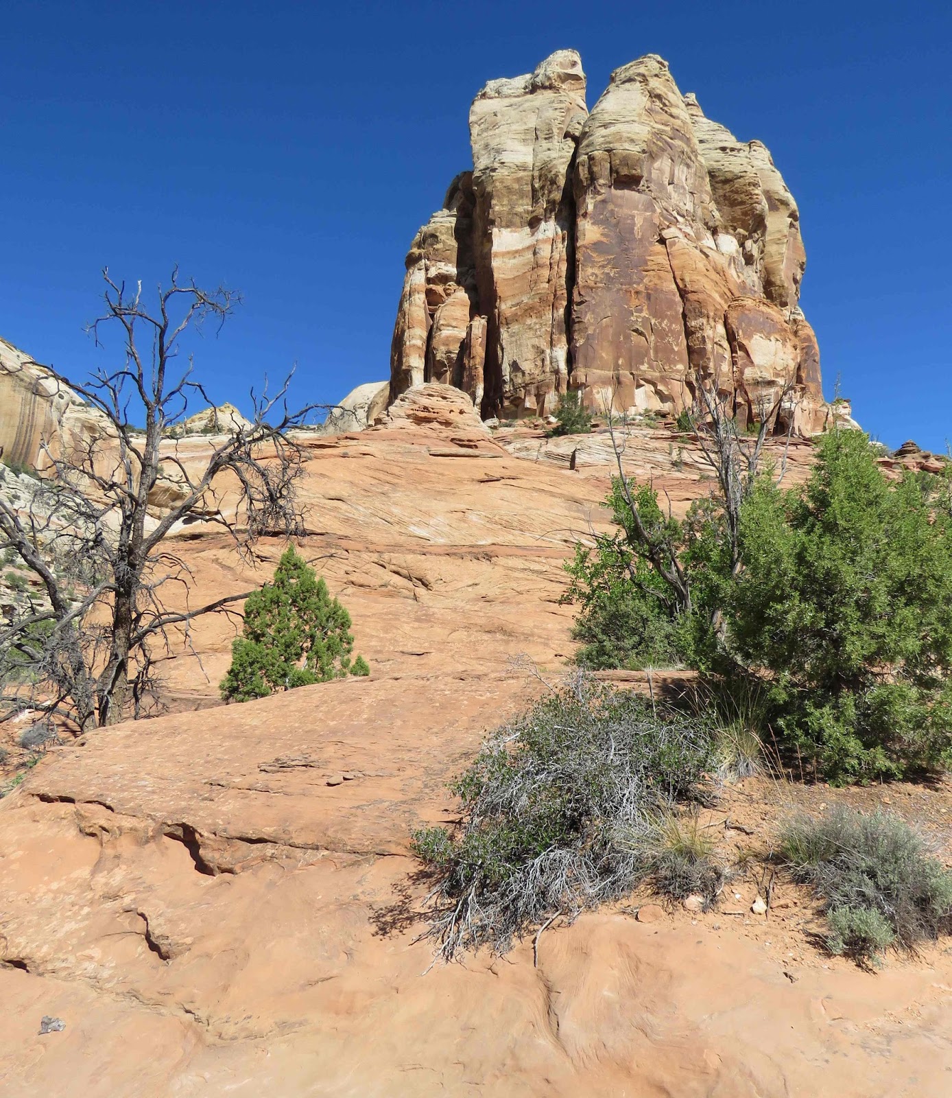
It's a bit cool this morning - upper 40s. But the sun is shining and the rock formations are wonderful. The creek that the trail follows still flowing at a pretty good clip (probably coming from the upper parts of Bryce which are over 8000ft).

I've been here a few times before -- the cave is the big draw (large icicles in the winter and dripping mossy cave otherwise) but the scenery is a can't miss as well.

I'm seeing a couple of yellow flowers this morning.

I follow the trail to the first bridge.

There's a lone male Mallard down there.

And he soon flies.

I continue onto the 2nd bridge. And after crossing, get my first view of the waterfall.

I reach the intersection - left goes to Mossy Cave; right goes to the waterfall - and I head right. It's just a short walk before I'm at the waterfall. And then behind the waterfall.

Time to head to Mossy Cave. (Still think it looks better in the winter.)

Glad I stopped!!

I head back to Bryce; the pronghorn are still there but they are standing now.

A few miles down the road, I see 2 more Pronghorn standing 100 ft off the road looking at the cars (hope they time the crossing properly).

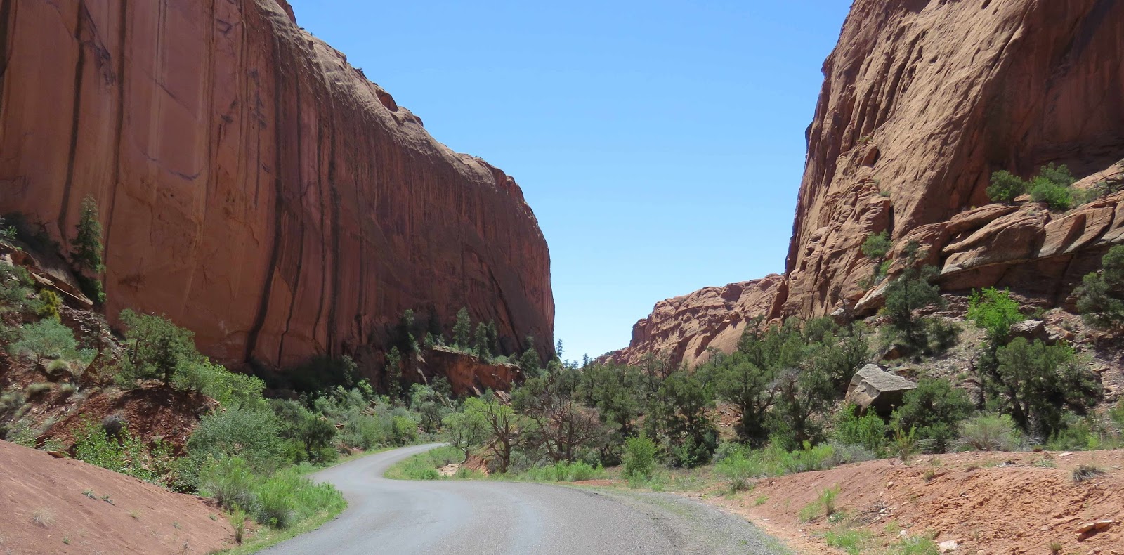
I'm heading for a short stop at Red Canyon; the Arches Trail specifically. I hiked this last March, hoping for more flowers in bloom.

If you're on HWY 12, you can't miss Rec Canyon as the road runs right thru the bright red rocks. I'm heading to the Losee Canyon Trailhead which is 2 miles down a dirt road on the west edge of Red Canyon. The trail is short -- only 0.8 miles starting at around 7000 ft and  gains only 100 ft). If I remember right, there are bunches of little arches to find.

I make it to the parking area and start by crossing a dry wash before reaching the trail. The trail is both in the sun & shade. I head counter-clockwise and soon find an old kiln.

I quickly notice a low growing flower (and plenty of them - white and pink ones); looks like Phlox. They are all along the trail.

And a few yellow flowers too.


But the star is the scenery -- arches, faces, ....


I reach the 1/2 way point -- the "looking" eyes.

I peer through one of the windows.


Here I see my only butterfly -- a White --- but I can' get a good look at it.

And a pretty little bird.

Wonderful stop, but it's time to head home.

I drive HWY 12 to 89N. I should turn-off at the Beaver Exit as it will get me to the "quicker" I-15 sooner. But I decide to be different and continue taking 89 north to see what lies ahead. (And besides, I'm the only car on the road, the 5 cars in front of me turned towards Beaver.)

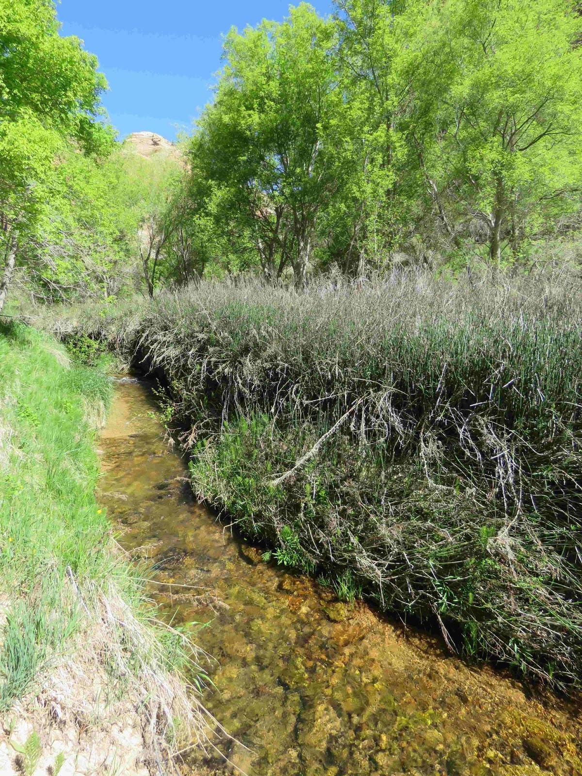
The road follows a creek the whole way. The first part was a wetland / ranch land -- beautifully green (many shades). Plenty of cows too. But along the way, I spot one Sandhill Crane in among the cattle.

There are mountains to the west -- some of the higher peaks still have snow on them.

But after Maryland (small town), the road enters a curvy canyon (stream still right next to the road). The rocks are some many different colors -- there are sections of yellow, red, brown and something that looks a little like purple. So glad I took this route. Highly recommend if you enjoy scenery (and have the time).

I finally reach I-70, head west to I-15 and then north. The only deer of the day was along the I-15 just before entering Nephi.

Wonderful day and trip!!

May 5 - Lower Calf Creek Falls

Well, I've thought about it for 4 years now, but this week-end I'm FINALLY heading down to Boulder UT (in the Bryce Canyon & Capitol Reef area) to hike Lower Calf Creek Falls. The photos I've seen are pretty stunning so it's more than time to see it live.

Heading down part way (Richfield UT) on Thursday after work - knocks 2.5hrs off a 4.5 hr drive. The mountains heading down I-15 look like upside down snow cones (snow only on the tops) and the ground is various shades of green from all the snow and rain we've gotten over the winter and
so far this Spring.

As always, plenty of cattle (with little calves too) and horses.

But what is really incredible as I drive windows down, along the highway is this wonderful smell! No, not manure (although it was some what strong in spots); but this mildly sweet buttered popcorn smell. The smell is all along the highway where the ranch land is. The smell reminds me of a prairie grass called Prairie Dropseed. This low growing dainty grass, when in bloom in July/Aug, has a similar smell. I doubt Prairie Dropseed grows here but possibly a relative or another native grass that's in bloom now. Wonderful wonderful smell!!!

Now to today (Friday),...

It's a beautiful sunny morning in the mid-40s. Heading into the 80s today. I head out east from Richfield; still many cows (and babies - some of them hard to see as they a flat against the ground "hiding").

As I get higher in elevation, the cows are replaced by sheep and when I drop in elevation again, the cows reappear.

As I get closer to Torrey (the entrance to Capitol Reef National Park), I can start seeing the rocky landscape.

I reach Torrey but instead of entering the park, I turn south on HWY 12 towards Boulder. As I head south, I leave the ranchland and the rock formations and head up a mountain into aspen/pine
country. Quite the drastic change from what I've already driven through but it's very beautiful. The aspen has not yet leafed; there's still snow on the ground in spots (a good amount of snow).

I startle one deer along the way and brake for a marmot (or a very large/fat ground squirrel). I keep climbing until I reach the summit at 9600ft. Snow still covers the landscape at the summit. But in front of me is once again that beautiful rock landscape.

Pretty impressive. But the views soon disappear as I head back into the forest.

As I'm coming down the mountain and rounding a bend, I see 4 deer standing on the edge of the road all looking at me. I slam on my brakes...thankfully, the deer do the right thing and run into the forest instead of across the highway. Whew!

A little further down, I reach a side road that heads to the Deer Peak trail. I slow just to check if the road might  be doable with my car. I see at least 10 deer the trail -- aptly named trail I guess.

Soon I reach Boulder (a very small town) and pass the Burr Trail road - I'll be driving later today as getting to the Lower Creek Falls trail is at the top of my list (and before it's gets too crowded). The trail is still 15'sh miles ahead....across the Hogsback.

The Hogsback is HWY crossing the spine of this valley of white rocks. It's really should be on everyone's "must-see" list if you appreciate the power of Mother Nature. It's also a Hwy without mercy as for several miles there really isn't much of a road edge, no guardrails and it's a long way down. But it's extremely beautiful.

The only pull-off I know of is on the north edge and I do stop.

And then it's across the spine and I arrive at Lower Calf Creek!!

Several cars already parked when I arrive around 9:30; I get one of the two remaining spots. I grab my pack and plenty of water (already in the 70s) and head off on the 3 mile trail.

The trail is a wonderful mix of short stretches thru oaks, highly vegetated sections especially when near the creek, rock sections and plenty of sand - always changing, never getting boring.


I'm hiking below the Hogbacks so there are canyons walls.


All these different environments lead to plenty of singing birds (but they are extremely hard to find for some reason). I catch up to this one (Spotted Towhee -- with an attitude) who is constantly calling.

There are also several Vultures flying over the canyon walls.

The flowers are pretty incredible!! And this is just a few of them!


Even the trees and shrubs were blooming....


And even a cactus.


Lots of lizards scampering around the trail and thru the leaves.


The flowers are a good nectar source for the many butterflies I see. Besides Margined and Checkered Whites, Orange Sulpher, and Painted Ladies, Western and Two-tailed Swallowtails, I see Pacuvius Duskwing


Variable "Anicia" Checkerspots

and Common Checked Skippers on the way to the Falls.


I know I'm getting close to the Falls when the canyon closes in,

it stays forested and the creek is right alongside the trail.

Finally, I get a glimpse of the 130 ft falls ahead of me. I actually pass up some butterflies puddling (believe it or not, the Falls is more important right now).

And there she is - Lower Calf Creek Falls!! Amazing!!!


(There's only one group of people here and they are all huddled together under the trees...I got here in time!)

I stay for a bit and when I start heading back, there's many many people coming down the trail.

Now that I'm in no hurry, I do stop at that mud puddle and see a Two-tailed Swallowtail.


and Common Checkered Skippers.

A little further down the trail, I come upon another muddy section and find a couple of Variegated Frits.

As I wander back, I wonder with all this water where are the dragonflies? I only see one the entire trip. Maybe it's too early.

With all this water, one would expect to see dragonflies but I only see one the entire hike. Maybe it's still too early.

But the views are still mighty fine heading back!!


Awesome hike!!!! Highly recommended!

Well it's time for lunch and for that it's back across the Hogsback to Boulder - the Burr Trail Grill is next on my list. I have a wonderful lunch (and great Apple Pie) then I'm off for a drive down the Burr Trail Road.

The Burr Trail Road is a 69 mile road from Boulder across Capitol Reef to Bullfrog. Only the first 30 miles from Boulder are paved and that's as far as I will be going today.

I've been on this road once before on a hiking trip; it was a very rainy day and the canyon walls had streams of water flowing over them - very pretty.

Well there's no rain in the forecast today so the dry scenery will have to do. As I head down the road, it start as ranch land/cows and then abruptly switches to white rock.

Further down, I reach red rock.

Then I drive down a few switchbacks into the canyon.

At the mile 11 mark is a small slot canyon ("Singing Canyon").

I continue down the road for only 15 miles before I turned around.

On the way out, I stop at the top of the switchbacks to look where I had just been.

Then it's back across the Hogsback one last time as I head for my hotel in Tropic (outside of Bryce). I make a few stops along the way for the views.

Awesome day!

Sunday, May 7, 2017

May 7 - Mormon Trail -- East Canyon Trail

It's a sunny morning and the temps today only near 80 degrees (a bit cooler than the 85 degrees of the last couple of day). But it's still 10 degrees warmer than normal and from what I've heard on the news, the run-off is in full flow now and towns are prepping for flooding. (Need some more "normal" temps to slow things down.)

I debated about heading into the mountains -- Cardiff Fork (Mill D South) --- or the Mormon Trail. The Mormon Trail wins -- I want to see butterflies! I was at the Mormon Trail 3 weeks ago and didn't get very far as the first stream crossing was very flooded. I'm hoping that has receded just a bit to expose some rocks and logs so crossing is possible.

But as I drive along the dirt road to the trail head, I notice the creeks are very high - much higher than 3 weeks ago. I have a funny feeling, I'm not going to be hiking very far today.

I park and head off on a very muddy trail and a very high stream. I just cross the bridge when I meet 4 hunters on their way out (turkey hunters -- they saw no turkeys) who warn me of the impending flooding. Say they've never seen it so high. I continue on and meet a pack of muddy/wet dogs and their walker. She too warns me of river head. Still I continue on thru the woods -- I haven't yet reach the actual trail yet but I can hear the rushing waters.

I reach the trail -- still no flowers in bloom other than the dandelions and these - Groundsel (I think).

I start up the trail and soon run into a small stream on the trail; that's easy to get around but not too much further ahead, the trail "stream" is bigger and flowing. It's still passable if I want to get wet because there is dry trail ahead (I can see it). But I know I'll only get stopped where I was 3 weeks ago but this time it'll be deeper. And there'll be more flooding even further down the trail. Time to turn back.  Maybe in a couple weeks....

So what to do next, Lamb's Canyon is still closed. I've never seen it closed before; people snowshoe it in the winter. Perhaps it's closed due to damage from an avalanche this winter. Don't know.

That leaves East Canyon again. I walked it 2-3 weeks ago but I'm doing it again. There were some bflys that time; hopefully more now.

I get to East Canyon (Little Dell Reservoir) and it's under a big black cloud. So much for bflies but it will be a nice walk.

There are more Balsamroot (Largeleaf) in bloom

and more Groundsel.

I head down to the far north end of the Reservoir. I see a Painted Lady but it flies off.

I also hear Kildeer. It takes me a while but I track down one of them.

Continuing on, I see a new bloomer -- Puccoon!

And a couple of BlueBells.

I'm hearing lots of birds but they're really hard to find.

The trail is finally close enough to the creek to take good luck at the rushing water.

On my way, I see a Hummingbird Moth and a White butterfly. Too quick for photos though.

I finally reach the road and this is my turn around for today. Of course, the sun is out now but I want to take the road back.

I do see 2 Painted Ladies and a Sulpher on the way to my car.

I can also still hear the birds calling as I head down the road. At one point, there are dueling calls. I finally track down the first bird between the branches -- a Yellow Warbler!

Across the street, I find a Spotted Towhee!

I see another Yellow Warbler along the way and in the open. But he flies!

Good day!